Menu:
National Parks
The approximate route is shown by a blue line.
Use your mouse to drag the map to the area of interest and
zoom in/out using the controls on the left hand side of the map.
Please use my map to find the route on your own large scale
walking map such as the OS Explorer series at 1:25000.
If you have time if you do this walk please let me know how you get on.
That would be very helpful to me to keep my information accurate and up to date.
Please note that I provide this free service to you as a fellow walker on the
understanding that you walk
the route entirely at your own risk and that the information is not used for
any commercial purpose.
Library route no. 930310
Grassington, River Wharfe, Hebden, Hebden Beck,
Bycliffe, Conistone Dib, Conistone, circuit - 23km
Yorkshire Dales . . .
Map: OS Explorer OL2 Yorkshire Dales Southern & Western areas at 1:25000
General Directions (see markers on the route map)
1.) Start at the Visitor centre and car park at Grassington, map ref. SE002637. From the southern corner of the car park take the footpath down Sedber Lane to the River Wharfe where there is a footbridge over the river by the weir and Linton Falls. Do not cross the footbridge, but turn left to follow the path, part of the Dales Way, along the riverside to the pedestrian suspension bridge over the river at Hebden Beck.
2.) Here turn away from the river and follow the path up the valley of Hebden Beck to Hebden village. At the village cross the main road (B6265) at map ref. SE025631, and continue on a public right of way along the track opposite following Hebden Beck upstream for about 3km to map ref. SE024657. Here the track turns away from the beck and climbs across the moor for about 1km to a road at Yarnbury at map ref. SE015658.
3.) At the road turn right and follow the road which soon becomes an access track, called Old Moor Lane, across open access land of the wild high hillside. The track climbs over Bycliffe Hill and across the hills to just before Mossdale Scar where the track drops down to join the track coming across the hills from Nidderdale at map ref. SE011694.
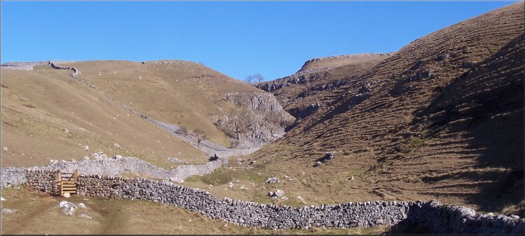
4.) There is a public footpath along the track from Nidderdale. Follow this path for almost 3km until it crosses the Dales Way at map ref. SD992682. Here turn left off the track to follow the path down the limestone gorge of Conistone Dib to Conistone village.
5.) At the road junction in the village at map ref. SD981674, turn left and
follow the road South. After about 150m turn left off the road on to a path
climbing up the hillside. This path follows the cliffs round the head of the
deep limestone side valley of Dib Beck and follows the edge of some woodland
to join the Dales Way route. Follow the Dales Way route back into Grassington
and the end of the walk.
(top of page)