Menu:
National Parks
The approximate route is shown by a blue line.
Use your mouse to drag the map to the area of interest and
zoom in/out using the controls on the left hand side of the map.
Please use my map to find the route on your own large scale
walking map such as the OS Explorer series at 1:25000.
If you have time if you do this walk please let me know how you get on.
That would be very helpful to me to keep my information accurate and up to date.
Please note that I provide this free service to you as a fellow walker on the
understanding that you walk
the route entirely at your own risk and that the information is not used for
any commercial purpose.
Library Route No. 951118
Fox & Rabbit, Farwath, Levisham, Grime Moor,
Bridestones, Stain Dale circuit - 16km
North York Moors . . .
Map: OS Explorer OL27 North York Moors Eastern area
General Directions (see markers on the route map)
1.) Start on the A169 opposite the Fox & Rabbit pub at map ref. SE844882. There is a wide grass verge here with room to park off the road. Take the farm access road opposite the Fox & Rabbit pub heading west. After about 400m the road bends to the right. Keep straight on here along a track to a field gate and through the gate follow the public bridleway down the steep hillside through Cross Dale. At the bottom of the slope follow the bridleway to the right towards Farwath. At map ref. SE830883 turn right to follow the bridleway along an old track called Sleights Road. Continue along this track for about 1.6km to the junction in the track at map ref. SE835900. At the junction keep left and follow the bridleway across the valley bottom and over a footbridge across the beck, then climbing up past the Valley Church of St. Mary the Virgin and then around the bottom edge of some woodland to the road at map ref. SE833902.
2.) At the road turn left and walk up the hill for about 50m then turn right off the road to follow the public footpath up to the wall at the boundary of the woodland and fields. Where the path forks below the wall keep to the right hand fork heading down the hillside. Cross the beck in the bottom on the footbridge and follow the path up Wedland Slack (usually quite muddy here). At map ref. SE846900 where there is a junction in the path turn left to almost double back and follow the path (not well used & may be overgrown) out to the A169 at map ref. SE850907. Cross the road and take the footpath opposite across the fields to the road next to Mount Pleasant Farm.
3.) At the road at Mount Pleasant farm turn left and walk along the road for about 150m to High House Farm. Here turn left off the road to follow the public footpath along the farm access track through High House farm and out across the large fields on Grime Moor where large herds of beef cattle graze. At map ref. SE870922, about 1.5km from High House Farm, there is a junction in the paths next to a small pond. Keep straight on at the junction and follow the path (not well walked) across the rough moorland for about 300m to a stony moorland access track. At this track turn right and follow the track for about 1km to map ref. SE876914.
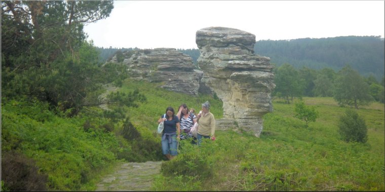
4.) At map ref. SE876914 turn right off the track to follow a footpath across the moor for about 250m to the start of the Bridestones. Don't stay on the moor top. Take the path a few metres down the valley side and then along the valley passing next to the "Low Bridestones". There are more of these wind eroded rocks visible across the valley. Continue along this path past the wind eroded rocks of the Bridestones for about 450m to map ref. SE873909. Turn right here to follow a footpath down into the little valley of Dove Dale. In the valley bottom turn left and follow the footpath along the valley bottom for about 350m to the fields beyond the woodland. Turn right here and follow the footpath past the little farmstead of Low Staindale (years ago this building was a youth hostel). From Low Staindale continue along the footpath along Stain Dale for about 2.5km to Staindale Lodge. Follow the path past Staindale Lodge and bending round to the left to continue down the valley. About 400m beyond Staindale Lodge turn off the path heading down the valley and follow the path climbing up the hillside through the forest plantation and then across the fields back to the Fox & Rabbit pub and the end of the walk.
(top of page)