| 2001 walks | 2002
walks | 2003 walks | 2004
walks |
| 2005 walks | 2006
walks | 2007 walks | 2008
walks |
| 2009 walks | 2010
walks | 2011 walks | 2012 walks |
| 2013 walks | 2014 walks | 2015 walks | 2016 walks |
| 2017 walks | 2018 walks | 2019 walks |2020 walks |
| 2021 walks | 1993-2000 library | Find a Route Index |
| A few Routes to print out | Request a Route... |
Route No 34 - 12 February 2002
Saltergate, Malo Cross, Lilla Howe
Simon Howe circuit - 12 miles
Newtondale,
North York Moors
Route map from Ordnance Survey Open Space service.
Map: OS Outdoor Leisure 27 North York Moors Eastern area. 1:25000
 My neighbour,
Jim, and I set off just before 9.00 this morning for a longer
walk than usual. We are in training. Jim's wife has agreed to
him joining me for a week's walking in Andalucia in April so we
are trying to get fitter to make the most of our trip. We parked
at the Hole of Horcum car park on the Pickering/Whitby road at
about 15 mins to 10. There were a few cars about but no other
walkers that we could see. We headed north from the car park up
the main road for a hundred yards before tuning right onto the
Old Wife's Way. Again after a hundred yards we turned left down
the back of the woods to the edge overlooking the Saltergate Inn
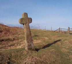
and in the distance the Fylingdales base. We walked about a mile
round the edge of Saltergate Brow to Malo Cross, one of the many
old stone crosses of the moors.
My neighbour,
Jim, and I set off just before 9.00 this morning for a longer
walk than usual. We are in training. Jim's wife has agreed to
him joining me for a week's walking in Andalucia in April so we
are trying to get fitter to make the most of our trip. We parked
at the Hole of Horcum car park on the Pickering/Whitby road at
about 15 mins to 10. There were a few cars about but no other
walkers that we could see. We headed north from the car park up
the main road for a hundred yards before tuning right onto the
Old Wife's Way. Again after a hundred yards we turned left down
the back of the woods to the edge overlooking the Saltergate Inn
and in the distance the Fylingdales base. We walked about a mile
round the edge of Saltergate Brow to Malo Cross, one of the many
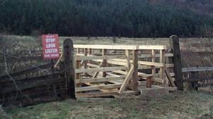
old stone crosses of the moors.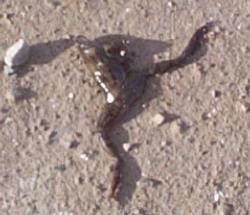 At the cross we turned left onto the marshy path along the side
of the forest for just over a mile. At this point the path reaches
a wooden gate and through the gate we turned right to keep on
a track still following the edge of the forested area. We stayed
on this stony track for another mile and a half to the end of
the forest. Before leaving the shelter of the forest we sat under
the trees away from the strong blustery wind for a drink and a
sandwich. Much of this first part of the route is running around
the boundary fence of the Fylingdales base. After our break we
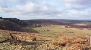
continued on the same track as far as Lilla Howe. Along the way
we saw an adult frog apparently uninjured but lying dead on the
track. It seems a bit early in the year for frogs to be out and
about, maybe it's the funny climate these days. There was a good
view from the track out to the coast south of Ravenscar. At Lilla
Howe we turned left onto the Lyke Wake Walk and headed down the
moor for 2 miles to the Pickering/Whitby road at Eller Beck.
At the cross we turned left onto the marshy path along the side
of the forest for just over a mile. At this point the path reaches
a wooden gate and through the gate we turned right to keep on
a track still following the edge of the forested area. We stayed
on this stony track for another mile and a half to the end of
the forest. Before leaving the shelter of the forest we sat under
the trees away from the strong blustery wind for a drink and a
sandwich. Much of this first part of the route is running around
the boundary fence of the Fylingdales base. After our break we
continued on the same track as far as Lilla Howe. Along the way
we saw an adult frog apparently uninjured but lying dead on the
track. It seems a bit early in the year for frogs to be out and
about, maybe it's the funny climate these days. There was a good
view from the track out to the coast south of Ravenscar. At Lilla
Howe we turned left onto the Lyke Wake Walk and headed down the
moor for 2 miles to the Pickering/Whitby road at Eller Beck.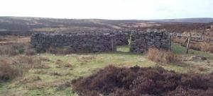 The path was very wet the whole way. At Eller Beck a car had run
completely off the road and was stuck nose first in a wet gully
about 30 yards from the road. It must have been going like the
clappers. As we stood staring at it a recovery truck pulled up
and a young man got out to inspect the job. He did not seem to
come to any immediate conclusion as to how to deal with the situation
and after exchanging a few pleasantries we continued on our way.
We headed west on the Lyke Wake Walk across the Fen Bog nature
reserve to the North York Moors Railway and on up to Simon Howe
about 2 miles from Eller Beck.
The path was very wet the whole way. At Eller Beck a car had run
completely off the road and was stuck nose first in a wet gully
about 30 yards from the road. It must have been going like the
clappers. As we stood staring at it a recovery truck pulled up
and a young man got out to inspect the job. He did not seem to
come to any immediate conclusion as to how to deal with the situation
and after exchanging a few pleasantries we continued on our way.
We headed west on the Lyke Wake Walk across the Fen Bog nature
reserve to the North York Moors Railway and on up to Simon Howe
about 2 miles from Eller Beck.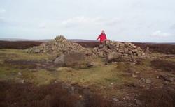 About half a mile before we reached Simon Howe we turned for a
last look at the view and the recovery truck was there in the
distance with its orange lights flashing. The situation was clearly
still under review. We turned onto Simon Howe Rigg in a southerly
direction and after about a mile came to a large dry stone wall
built in a 90 degree arc as a shelter for the moorland sheep.
It provided us with a comfortable spot to stop for another break
with a pleasant view over the moor to the forest ahead. After
the break we continued down the slope and over a wooden footbridge
across the stream to enter the forested area at Wardle Green (a
ruined farmstead). We turned left onto the stone forest track
heading towards Newtondale. We followed this track for about a
quarter of a mile to a junction with another stone track and here
continued straight ahead on a boggy mud track through the trees
to the edge of Newtondale.
About half a mile before we reached Simon Howe we turned for a
last look at the view and the recovery truck was there in the
distance with its orange lights flashing. The situation was clearly
still under review. We turned onto Simon Howe Rigg in a southerly
direction and after about a mile came to a large dry stone wall
built in a 90 degree arc as a shelter for the moorland sheep.
It provided us with a comfortable spot to stop for another break
with a pleasant view over the moor to the forest ahead. After
the break we continued down the slope and over a wooden footbridge
across the stream to enter the forested area at Wardle Green (a
ruined farmstead). We turned left onto the stone forest track
heading towards Newtondale. We followed this track for about a
quarter of a mile to a junction with another stone track and here
continued straight ahead on a boggy mud track through the trees
to the edge of Newtondale.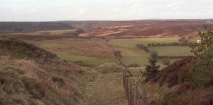 Here we followed the track as it turned to the right along the
edge of the steep slope into the valley bottom. At several places
the track is blocked by fallen trees and there are well walked
diversions around the obstructions. After almost half a mile around
the edge of the valley there is a wooden seat at the side of the
track where we stopped for a final drink. Just behind the seat
is a steep path down the side of the valley to the stone road
in the bottom beside the North York Moors Railway. Once on this
stone track we turned right to walk along beside the railway for
about 300 yards to a path on the left.
Here we followed the track as it turned to the right along the
edge of the steep slope into the valley bottom. At several places
the track is blocked by fallen trees and there are well walked
diversions around the obstructions. After almost half a mile around
the edge of the valley there is a wooden seat at the side of the
track where we stopped for a final drink. Just behind the seat
is a steep path down the side of the valley to the stone road
in the bottom beside the North York Moors Railway. Once on this
stone track we turned right to walk along beside the railway for
about 300 yards to a path on the left.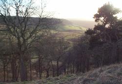 Where the path leaves the stone road there is a post that should
have half a dozen fire beaters hanging on it but the wind has
usually blown them onto the floor. The path leads to a crossing
of the railway and then to a new wooden footbridge over the stream.
We followed this path round the edge of the wood where it is very
marshy and then up a steep climb up the side of a very pretty
side valley. At the top we came onto the open moor and crossed
to the hairpin bend on the Pickering/Whitby road near the Hole
of Horcum. At the main road it was only a few hundred yards up
the hill back to the car park where we had started just over six
hours earlier. The whole route was a little over 12 miles. In
all that distance we had not seen a single other walker or cyclist
all day.
Where the path leaves the stone road there is a post that should
have half a dozen fire beaters hanging on it but the wind has
usually blown them onto the floor. The path leads to a crossing
of the railway and then to a new wooden footbridge over the stream.
We followed this path round the edge of the wood where it is very
marshy and then up a steep climb up the side of a very pretty
side valley. At the top we came onto the open moor and crossed
to the hairpin bend on the Pickering/Whitby road near the Hole
of Horcum. At the main road it was only a few hundred yards up
the hill back to the car park where we had started just over six
hours earlier. The whole route was a little over 12 miles. In
all that distance we had not seen a single other walker or cyclist
all day.