| 2001 walks | 2002
walks | 2003 walks | 2004
walks |
| 2005 walks | 2006
walks | 2007 walks | 2008
walks |
| 2009 walks | 2010
walks | 2011 walks | 2012 walks |
| 2013 walks | 2014 walks | 2015 walks | 2016 walks |
| 2017 walks | 2018 walks | 2019 walks |2020 walks |
| 2021 walks | 1993-2000 library | Find a Route Index |
| A few Routes to print out | Request a Route... |
Route No 42 - 7 March 2002
Forge Valley, Hutton Buscel, Wykeham Forest, Sea Cut, Raincliffe
Woods circuit - 11 miles
Scarborough, North York Moors . . .
Route map from Ordnance Survey Open Space service.
Map: OS Explorer OL27 North York Moors Eastern area. 1:25000
 To-day we drove
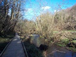
to Forge Valley on the River Derwent near Scarborough. It was
a lovely bright morning with a strong wind. We stopped in a small
car park by the river where there is a wooden footbridge over
the river to a boardwalk that runs for about a mile along the
river bank making it easily accessible for people in wheelchairs
or pushchairs. We headed downstream towards the village of West
Ayton. At the end of the boardwalk the path is very muddy and
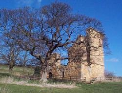
runs around the edge of a field passing the ruins of Ayton Castle.
To-day we drove
to Forge Valley on the River Derwent near Scarborough. It was
a lovely bright morning with a strong wind. We stopped in a small
car park by the river where there is a wooden footbridge over
the river to a boardwalk that runs for about a mile along the
river bank making it easily accessible for people in wheelchairs
or pushchairs. We headed downstream towards the village of West
Ayton. At the end of the boardwalk the path is very muddy and
runs around the edge of a field passing the ruins of Ayton Castle.
 We
came out passed some cottages onto a lane where we turned right
to head north west for a few hundred yards before turning left
onto a bridleway that brought us into the village of Hutton Buscel.
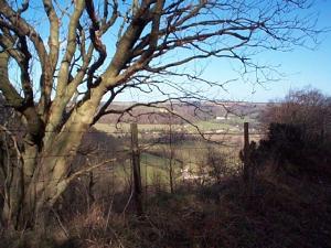
We walked along the village street for almost half a mile and
just beyond the village church we turned right on to a lane called
Great Moor Road on the map. The lane becomes a stone forest track
and after a couple of miles we stopped for a drink. There was
an ash tree covered in moss which was dry and soft and very comfortable
to lean against and enjoy the warmth of the spring sunshine. About
three and a half miles from Hutton Buscel we came to a five way
junction of stone forest tracks.
We
came out passed some cottages onto a lane where we turned right
to head north west for a few hundred yards before turning left
onto a bridleway that brought us into the village of Hutton Buscel.
We walked along the village street for almost half a mile and
just beyond the village church we turned right on to a lane called
Great Moor Road on the map. The lane becomes a stone forest track
and after a couple of miles we stopped for a drink. There was
an ash tree covered in moss which was dry and soft and very comfortable
to lean against and enjoy the warmth of the spring sunshine. About
three and a half miles from Hutton Buscel we came to a five way
junction of stone forest tracks. 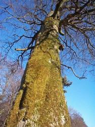 Here
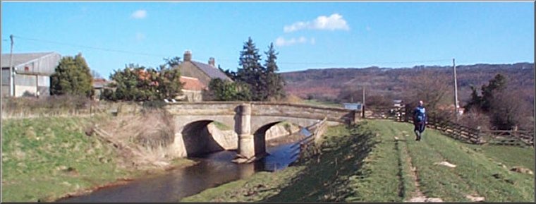
we turned right on to a track leading steeply downhill to a hamlet
called Wrench Green. From Wrench Green we followed the road to Mowthorp Bridge over the Sea Cut. The Sea Cut is an overflow
arrangement on the River Derwent where high river flows are diverted
into a canal called the Sea Cut that takes the water five miles
to the coast at Scalby Mills on the northern edge of Scarborough.
At this point there is no public right of way along the Sea Cut upstream of Mowthorp Bridge
but there is a footpath for anglers to get access to the water. As we reached the bridge
three herons flew up from the angler's path and glided into the damp field between
the Sea Cut and the river, to join six other herons standing in
the field. I must admit I have not seen so many herons all together
before.
Here
we turned right on to a track leading steeply downhill to a hamlet
called Wrench Green. From Wrench Green we followed the road to Mowthorp Bridge over the Sea Cut. The Sea Cut is an overflow
arrangement on the River Derwent where high river flows are diverted
into a canal called the Sea Cut that takes the water five miles
to the coast at Scalby Mills on the northern edge of Scarborough.
At this point there is no public right of way along the Sea Cut upstream of Mowthorp Bridge
but there is a footpath for anglers to get access to the water. As we reached the bridge
three herons flew up from the angler's path and glided into the damp field between
the Sea Cut and the river, to join six other herons standing in
the field. I must admit I have not seen so many herons all together
before.  We
turned off the road at Mowthorp Bridge and walked downstream along the Sea Cut until we reached the edge of the Scarborough
built up area. We turned right on to the road that skirted the
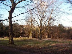
housing for about half a mile to Throxenby Mere. We turned into
Raincliffe Woods and climbed up to a track called Lady Mildred's
Ride and continued around the hill until we were at a point just
above the car park. There is a small stream flowing down the hill
side here. It passes under the path in a pipe which extends out
beyond the path for a foot or so allowing the water to cascade
down. This is a landmark to look out for. A few yards passed this
stream there is a path straight down the hill to the road opposite
the car park. The path is not well defined to start with but gets
clearer as you descend. It emerges onto the road beside the stream
dowm some stone steps next to a stone water trough. The whole
route is about 13 miles but it's all easy going with little climbing
and including our stops the route took us about five and a half
hours. You could make a very pleasant route of about 8 miles by
setting off from the car park upsteam on the boardwalk and continuing
across the fields past the Sea Cut to Wrench Green and then completing the final
part of our walk along the road and the Sea Cut and then back through Raincliffe
Woods.
We
turned off the road at Mowthorp Bridge and walked downstream along the Sea Cut until we reached the edge of the Scarborough
built up area. We turned right on to the road that skirted the
housing for about half a mile to Throxenby Mere. We turned into
Raincliffe Woods and climbed up to a track called Lady Mildred's
Ride and continued around the hill until we were at a point just
above the car park. There is a small stream flowing down the hill
side here. It passes under the path in a pipe which extends out
beyond the path for a foot or so allowing the water to cascade
down. This is a landmark to look out for. A few yards passed this
stream there is a path straight down the hill to the road opposite
the car park. The path is not well defined to start with but gets
clearer as you descend. It emerges onto the road beside the stream
dowm some stone steps next to a stone water trough. The whole
route is about 13 miles but it's all easy going with little climbing
and including our stops the route took us about five and a half
hours. You could make a very pleasant route of about 8 miles by
setting off from the car park upsteam on the boardwalk and continuing
across the fields past the Sea Cut to Wrench Green and then completing the final
part of our walk along the road and the Sea Cut and then back through Raincliffe
Woods.