|
 This morning
was bright and very pleasant but some rain was forecast for later
in the afternoon. We drove to Stump Cross Cavern on the Pately
Bridge to Grassington road near Greenhow. A few hundred yards
on the Grassington side of the cavern is a small muddy area where
we could park off the road. We were keen to get going to make
the most of the good weather and we began walking at about a quarter
to ten. On the hillside opposite our car park there were two men
in camouflage jackets behaving rather oddly. They kept lying on
the ground and seemed to be reaching into the ground, I assumed
there must have been burrows of some kind but they were to far
away to be sure. This morning
was bright and very pleasant but some rain was forecast for later
in the afternoon. We drove to Stump Cross Cavern on the Pately
Bridge to Grassington road near Greenhow. A few hundred yards
on the Grassington side of the cavern is a small muddy area where
we could park off the road. We were keen to get going to make
the most of the good weather and we began walking at about a quarter
to ten. On the hillside opposite our car park there were two men
in camouflage jackets behaving rather oddly. They kept lying on
the ground and seemed to be reaching into the ground, I assumed
there must have been burrows of some kind but they were to far
away to be sure.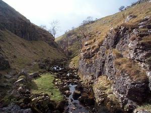 We set off along the road towards Grassington and after about
200 yards we turned left onto a rough stony track. A few yards
inside the gate a white car, with a sticker proclaiming "Wensleydale
Foxhounds Supporter", was parked. We continued along the track
for a quarter of a mile to a permissive path through a gate on
the right of the track. The pleasant green path leads down to
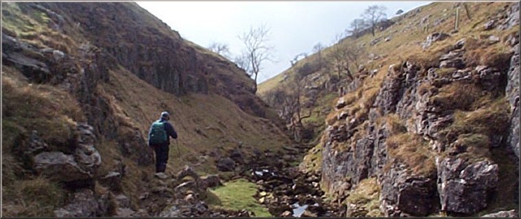
some old mine workings and the remains of a dam and stone spillway.
These remains are at the head of Trollers Gill - a limestone gorge
leading down the side of Wharfedale.
We set off along the road towards Grassington and after about
200 yards we turned left onto a rough stony track. A few yards
inside the gate a white car, with a sticker proclaiming "Wensleydale
Foxhounds Supporter", was parked. We continued along the track
for a quarter of a mile to a permissive path through a gate on
the right of the track. The pleasant green path leads down to
some old mine workings and the remains of a dam and stone spillway.
These remains are at the head of Trollers Gill - a limestone gorge
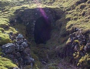
leading down the side of Wharfedale. 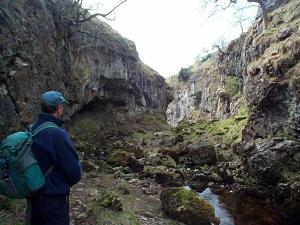 Skyreholme
Beck flows down the gorge and disappears down a series of sink
holes part way down to reappear just below the end of the gorge
in a series of lovely clear springs with watercress growing in
them. After the gorge there is another old breached dam from the
nineteenth century just above Parcevall Hall - a minor stately
home and gardens open to the public. From here we walked along
the lane through Skyreholme village and sat on a seat above the
road to have a break with a lovely view across Wharfedale and
a flock of noisy squabbling gulls in the field opposite. We continued
through Appletreewick village, full of lovely old stone buildings,
to a track down to the River Wharfe just beyond Low Hall. Skyreholme
Beck flows down the gorge and disappears down a series of sink
holes part way down to reappear just below the end of the gorge
in a series of lovely clear springs with watercress growing in
them. After the gorge there is another old breached dam from the
nineteenth century just above Parcevall Hall - a minor stately
home and gardens open to the public. From here we walked along
the lane through Skyreholme village and sat on a seat above the
road to have a break with a lovely view across Wharfedale and
a flock of noisy squabbling gulls in the field opposite. We continued
through Appletreewick village, full of lovely old stone buildings,
to a track down to the River Wharfe just beyond Low Hall. 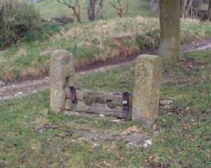 There
was a ewe in the field next to the track, clearly in labour and
we watched her for a while hoping to see a lamb born but her contractions
were not coming fast enough and we could have been there an hour
before there was any action so we pressed on up the river side
to Burnsall. We crossed the river at Burnsall and headed upstream
again. This is a lovely part of the River Wharfe with limestone
cliffs and rapids forming some really picturesque reaches. Just
before we came to the little suspension bridge that take pedestrians
over the river to Hebden, we stopped to watch a dipper flying
from rock to rock in the fast flowing river then diving under
water to pop up again next to another rock. It's amazing how such
a fragile creature can deal so expertly with the churning water
of the rapids. There
was a ewe in the field next to the track, clearly in labour and
we watched her for a while hoping to see a lamb born but her contractions
were not coming fast enough and we could have been there an hour
before there was any action so we pressed on up the river side
to Burnsall. We crossed the river at Burnsall and headed upstream
again. This is a lovely part of the River Wharfe with limestone
cliffs and rapids forming some really picturesque reaches. Just
before we came to the little suspension bridge that take pedestrians
over the river to Hebden, we stopped to watch a dipper flying
from rock to rock in the fast flowing river then diving under
water to pop up again next to another rock. It's amazing how such
a fragile creature can deal so expertly with the churning water
of the rapids. 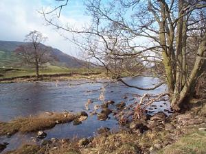 We
crossed the river and climbed up the valley side to Bank Top on
the Pately Bridge/Grassington road. Just before the top we found
a dry-stone wall in the sunshine with a great view over Wharfedale
so we stopped for another break. It was very warm and comfortable
in the sun. At Bank Top we crossed the road and continued along
a track called Backstone Edge Lane on the map. After about two
miles on this track. There is a gate in the fence and a track
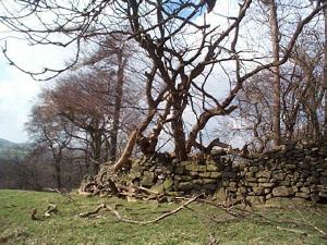
which lead through a couple of fields down to Hartlington Moor
Lane and then on to a permissive footpath around Grimwith reservoir.
There were lapwings and curlews all around us, filling the air
with their calls as we crossed the moor from Bank Top to the reservoir
- a lovely sign of spring. We
crossed the river and climbed up the valley side to Bank Top on
the Pately Bridge/Grassington road. Just before the top we found
a dry-stone wall in the sunshine with a great view over Wharfedale
so we stopped for another break. It was very warm and comfortable
in the sun. At Bank Top we crossed the road and continued along
a track called Backstone Edge Lane on the map. After about two
miles on this track. There is a gate in the fence and a track
which lead through a couple of fields down to Hartlington Moor
Lane and then on to a permissive footpath around Grimwith reservoir.
There were lapwings and curlews all around us, filling the air
with their calls as we crossed the moor from Bank Top to the reservoir
- a lovely sign of spring. 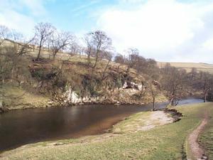 As
we crossed the dam there was a flock of oyster catchers, with
their distinctive orange legs and bills, all in a line on the
black concrete wall. I tried to get a photo but my camera chose
that moment to malfunction and by the time I was sorted out they
had all flown off. We walked through the picnic area to the far
end of the reservoir and took the footpath over the craggy limestone
hill (Knot Head & Nursery Knot) back to our car on the bend near
Stump Cross Cavern. The whole route had been about 12 miles and
had taken us about 6 hours including our stops. It's a very varied
route with a limestone gorge, wooded riverside, open moorland
and the reservoir. Quite strenuous but well worth the effort. As
we crossed the dam there was a flock of oyster catchers, with
their distinctive orange legs and bills, all in a line on the
black concrete wall. I tried to get a photo but my camera chose
that moment to malfunction and by the time I was sorted out they
had all flown off. We walked through the picnic area to the far
end of the reservoir and took the footpath over the craggy limestone
hill (Knot Head & Nursery Knot) back to our car on the bend near
Stump Cross Cavern. The whole route had been about 12 miles and
had taken us about 6 hours including our stops. It's a very varied
route with a limestone gorge, wooded riverside, open moorland
and the reservoir. Quite strenuous but well worth the effort.
|
Dry stonewall in the sunshine
|
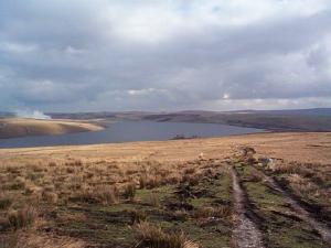
Grimwith Reservoir
|
|