| 2001 walks | 2002
walks | 2003 walks | 2004
walks |
| 2005 walks | 2006
walks | 2007 walks | 2008
walks |
| 2009 walks | 2010
walks | 2011 walks | 2012 walks |
| 2013 walks | 2014 walks | 2015 walks | 2016 walks |
| 2017 walks | 2018 walks | 2019 walks |2020 walks |
| 2021 walks | 1993-2000 library | Find a Route Index |
| A few Routes to print out | Request a Route... |
Route No.151 - Wednesday 3 August 2005
Cockayne, Bransdale Mill, Stump Cross,
Bloworth Crossing, Rudland Rigg - 13km.
North York Moors
Maps: OS Explorer OL26 North York Moors Western area at 1:25000
Route Map on 'Landranger' base
from OS Open Space service
| 
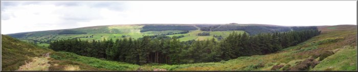
Bransdale
This morning my neighbour, Jim, and I drove to Bransdale
in the North York Moors. Our usual route from Helmsley was closed due
to the damage caused by the severe flooding on 20 June, so we had to
go via Fadmoor and Rudland Rigg. In Fadmoor we stopped at the organic
farm shop for some vegetables before heading into Bransdale. |
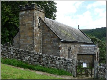
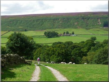
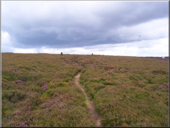
St Nicholas Church Cockayne
Looking back to Cockayne & the church from the track
The walk then goes East along the road which bends right after 300
metres and in a further 100 metres bends left. At this second corner
the route carries on through a farm gate onto a gravel track. From the
track there is a good view of Cockayne and the church. The track leads
in less than 500m to the old Bransdale Mill. |
The roads around the head of Bransdale are narrow and parking safely
off the road is not easy. There's a good place to park on the grass
verge just before the cattle grid by the T-junction (map ref. SE621984)
about 100 metres East of St Nicholas Church at Cockayne. The church
itself is well worth a visit.

Leaving the road at map ref. SE623983
The track leading to Brandsdale Mill
|
| 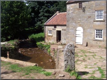
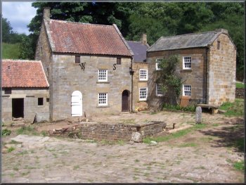
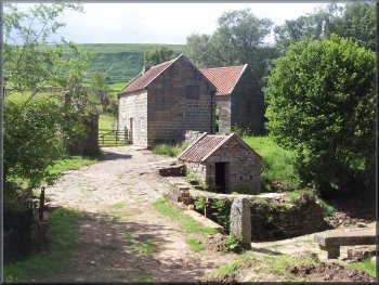
Bransdale Mill
Sundial in the field above Bransdale Mill
His son Emmanuel was the vicar at Ingleby Greenhow and he was responsible
for the inscription on the mill wall and the inscription on the Cammon
Stone on Rudland Rigg. From the mill we followed the path climbing up
to Colt House Farm. |
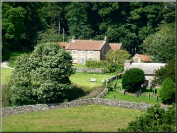
Bransdale
Mill is a National Trust property on Hodge Beck in the valley bottom,
and it is now used as a bunk house for youth groups. In the mid 1800's
the mill was owned and run by William Strickland.
Bransdale Mill
Sundial in the field above Bransdale Mill
|
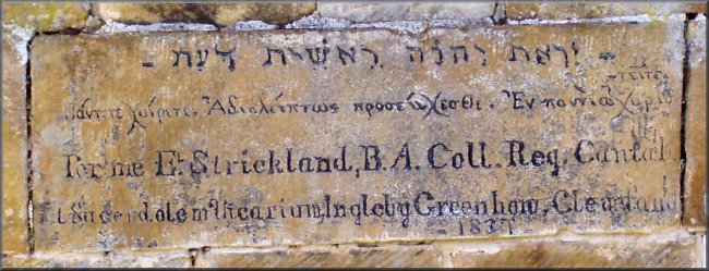
Inscription on Bransdale Mill in Hebrew, Greek and Latin |
Bransdale Mill
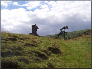
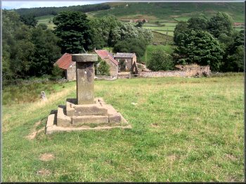
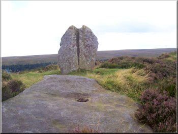
Stump Cross
Just beyond the cross we kept straight on instead of taking the public
footpath on the track to the left into Tripsdale. The new "Right
to Roam" under the CRoW
Act has given us the opportunity to explore some grouse shooters
tracks that were not previously open to the public. |
Opposite Colt House Farm at map ref. SE 615976 we followed the path
heading roughly west from the farm up the valley side. As we reached
the moor top we came to Stump
Cross at map ref. SE 606982.
Path from Bransdale up to Stump Cross
Grouse shooters track from Stump Cross
|
| 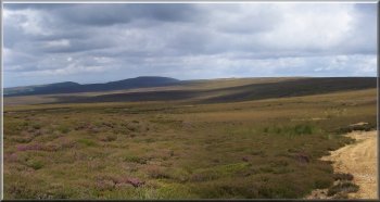
Looking to Cringle Moor from the track near Stump Cross
Here we turned right and followed the Cleveland Way to Bloworth Crossing
on the old ironstone railway that carried the ore from Rosedale and
Farndale to Middlesbrough. |
We continued on the track for about 2km to the Badger Stone at map
ref. NZ 604004 above Hodge Beck. We crossed the beck and followed the
track to the Cleveland Way at map ref. NZ 602015.
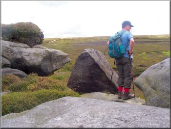 Jim
on the Badger Stone Jim
on the Badger Stone
|
| 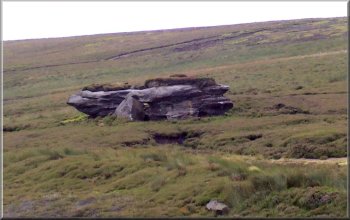
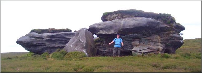
The Badger Stone
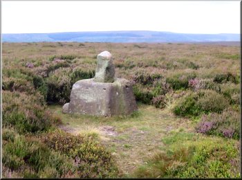
The Cammon Stone

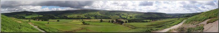
Looking over Bransdale on our way down from Rudland Rigg
Here the route turns right to follow the road back to
the starting point by the cattle grid in Cockayne. The whole route is
13km and it took us about 4 hours to walk including our lunch stop.
|
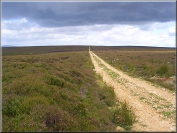
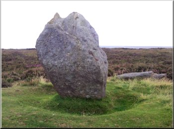
At Bloworth Crossing we turned right again onto the Rudland Rigg
track and after about 2km we came to the Cammon Stone at map ref, SE
626999. We continued along the rigg for another kilometre to map ref.
SE 631991 where we turned right on to a path down the valley side to
the road at map ref. SE 625982.
The Cammon Stone
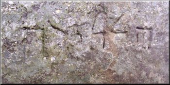
Inscription on the Cammon Stone

The track down from Rudland Rigg to the road near Cockayne
|
Bransdale from Rudland Rigg near the Cammon Stone |
Background Notes:
This route is a circuit of 13km, just over 8 miles, from the hamlet of Cockayne in Bransdale on the North York Moors. It's a very pretty place but not so well known as the neighbouring Farndale. The walk starts near the tiny church of St. Nicholas where the stone font is from an earlier medieval church. We follow the Hodge Beck down the valley to the old Bransdale Mill. This is a lovely range of stone buildings with red pantile roofs and it's all been restored in recent years, I think largely with the help of volunteers. The mill and the surrounding farmland is owned by the National Trust now and the mill is used as a bunk house and activity centre for groups of young people. In the mid 1800's the owner and miller was William Strickland. He had a son called Emmanual Strickland who became the vicar of Ingleby Greenhow on the northern edge of the North York Moors. On the wall of the mill building there is an inscription in Hebrew, Greek and Latin by Emmanual Strickland. As we leave the mill there is a large stone sundial in the field with inscriptions on each side. The inscriptions include the initials of William Strickland and the names of two of his masons who worked on the mill buildings. There is also the number AM5882. This is the number of years since God created the earth calculated according to the method devised by Archbishop Usher of Dublin, around 1600, based on his interpretation of the Bible. AM stands for Anno Mundi, meaning 'year of the world'. We continue to climb up the valley side to Stump Cross on the moor top. This is one of the many ancient moorland way mark crosses. The stone base is about 75cm square with the broken shaft of the cross still in place. There are several ancient routes across the moors in this area and Stump Cross is near the junction of two of them, one called the Thurkilsti going from Beadlam to Ingleby Greenhow, and the other is the Via Magna from Helmsley. Just beyond Stump Cross we follow a moorland track across open access land to the Badger Stone. This is a large outcrop of gritstone sitting in the middle of the heather moor overlooking the head waters of Hodge Beck. We continue across Hodge Beck and head northwards to a track that is on both the Cleveland Way and the Coast to Coast routes clse to the highest point on the North York Moors at 454m, or about 1500ft. Our route turns right to follow the Cleveland way route to Bloworth Crossing. This is where the Cleveland Way crosses the old ironstone railway at the end of Rudland Rigg. It is high on the open moor between the head of Farndale and the head of Bransdale. From here our route follows the track along Rudland Rigg for about 3km. Look out for the old stone way mark posts along the track. They had the destinations carved into them before there was any standardised spelling of words or placenames and the towns are spelt phonetically (in the local dialect). One example is spelt STOXLI and if you say it out loud it's obviously Stokesley. After about 2km along the Rudland Rigg track we reach the Cammon Stone to the east of the track. This is a large standing stone leaning at about 30 degrees and dating from the Neolithic period. Flints found here show the site was in use in the stone age.There is also a large flat slab next to it which it is suggested was also once standing upright. On the side of the Cammon Stone next to the track there is the word 'Halleluia' carved in Hebrew in letters about 75mm high. This was apparently the work of the Rev. Emmanuel Strickland from Bransdale Mill. About a kilometer beyond the Cammon Stone we turn off the track away from Rudland Rigg and here, a little way off the track in the heather, there is another broken moorland cross like Stump Cross and this one is called Cockram Cross marking another ancient cross roads where the track from Bransdale into Farndale crosses Rudland Rigg. We make our way down into Bransdale and back to our starting point at Cockayne and the end of our walk.
top of page
|