|
For
each of the last five years my neighbour, Jim, and I have
had a short walking holiday together.
In
1998 we walked the West Highland Way and have been to the
Lake District twice. Last year we spent a week in Northumberland.
This year we decided to go to the Sportsmans
Inn near Dent
for a few days.
|
Monday | Tuesday
| Wednesday | Thursday
|
|
Route No 71a - 31 March 2003
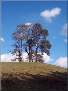
Aysgarth Falls Visitor Centre, River Ure, Nappa Hall,
Carperby, Aysgarth Lower Falls circuit - 16 km
Wensleydale . . .
Map: OS Explorer OL30 Yorkshire Dales Northern & Central areas at 1:25000
Route map from Ordnance Survey
Open Space service
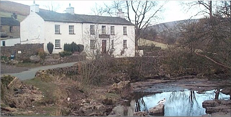
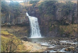
On
Monday 31 March we set off. It was quite a late start as
Jim had ordered a new car at the week end and needed to sort out
some details with the garage before we could leave. We drove up
Wensleydale to Aysgarth
and parked at the visitor centre (map Ref. SE 012888) It was already
midday so we went to the upper falls called High Force and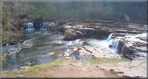 had our lunch on one of the picnic tables with a nice view of the
river and the falls. So it was about 12.30 when we finally got going
along the path upstream passed a farm called Bear Park. A few fields
beyond the farm is a sign provided by the National Park Service
informing walkers that the OS have wrongly marked the path on some
editions of the map (my map is quite elderly and was the one that
was wrong) so we followed the signs and everything was OK. The path
followed a disused railway for a few hundred metres before crossing
to the riverbank. We walked along the river and the disused railway
for about 4km to Nappa Mill (map ref. SD 961906).
had our lunch on one of the picnic tables with a nice view of the
river and the falls. So it was about 12.30 when we finally got going
along the path upstream passed a farm called Bear Park. A few fields
beyond the farm is a sign provided by the National Park Service
informing walkers that the OS have wrongly marked the path on some
editions of the map (my map is quite elderly and was the one that
was wrong) so we followed the signs and everything was OK. The path
followed a disused railway for a few hundred metres before crossing
to the riverbank. We walked along the river and the disused railway
for about 4km to Nappa Mill (map ref. SD 961906).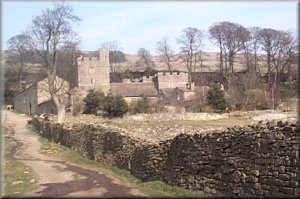 Here we almost turned back on our route to follow the path up hill
to Nappa
Hall. We turned left onto the road at Nappa Hall and after 200m
turned right on to a narrow lane climbing the hillside to map ref
SD 963917. Here we joined a bridleway that contoured round the valley
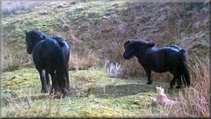
side above Woodhall towards Carperby. We came across an old pickup
truck parked beside the wall and with a fire burning strongly under
a large claypipe used as a chimney. There were three red hot branding
irons sticking out of the fire and we were intigued to find out
what was being branded - after all this is not the wild west! We
looked over the wall to see three people and several dogs herding
a huge flock of Swaledale sheep ready to brand their horns. A little
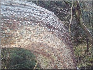
farther on, the path goes through some old lead mine workings where
the waste heap has congealed into a huge
Here we almost turned back on our route to follow the path up hill
to Nappa
Hall. We turned left onto the road at Nappa Hall and after 200m
turned right on to a narrow lane climbing the hillside to map ref
SD 963917. Here we joined a bridleway that contoured round the valley
side above Woodhall towards Carperby. We came across an old pickup
truck parked beside the wall and with a fire burning strongly under
a large claypipe used as a chimney. There were three red hot branding
irons sticking out of the fire and we were intigued to find out
what was being branded - after all this is not the wild west! We
looked over the wall to see three people and several dogs herding
a huge flock of Swaledale sheep ready to brand their horns. A little
farther on, the path goes through some old lead mine workings where
the waste heap has congealed into a huge 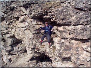 formation
pock-marked with small caves. The path here is called Oxclose Road
on the map. We turned off this path to descend into Carperby. From
the village we took the path across the fields (from Low Lane) back
to the visitor centre. We left our rucsacks in the car and walked
down stream to see the middle and lower falls. The sun was getting
low in the sky and was shining directly down stream making any photography
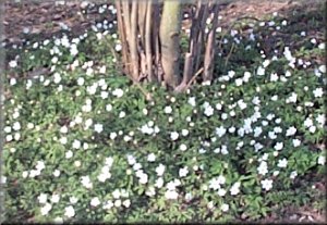
of the falls very difficult. The woods were carpeted with wood anenomies
- lovely delicate little flowers. The whole route was about 16km
and took us about four and a half hours including a couple of quite
long stops in the sun. We drove up to the Sportsmans Inn at Cowgill
near Dent and sampled the Black Sheep bitter until it was time to
eat. formation
pock-marked with small caves. The path here is called Oxclose Road
on the map. We turned off this path to descend into Carperby. From
the village we took the path across the fields (from Low Lane) back
to the visitor centre. We left our rucsacks in the car and walked
down stream to see the middle and lower falls. The sun was getting
low in the sky and was shining directly down stream making any photography
of the falls very difficult. The woods were carpeted with wood anenomies
- lovely delicate little flowers. The whole route was about 16km
and took us about four and a half hours including a couple of quite
long stops in the sun. We drove up to the Sportsmans Inn at Cowgill
near Dent and sampled the Black Sheep bitter until it was time to
eat.
(top)
 |
|
Map: OS Explorer OL2 Yorkshire Dales Southern & Western areas at 1:25000
 The
next day, Tuesday 1 April, the weather was bad. I woke
up to the sound of heavy rain, and from 7.00am to 8.30am the beck
in front of the pub rose by over a foot and turned from a clear
stream to a brownish torrent. Not a good sign. We decided to take
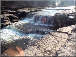
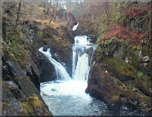
advantage of this weather and drove to Ingleton and walked the
7km round the
Ingleton Waterfalls Walk in the morning. The falls were quite
spectacular with plenty of water coming over. We had a very civilised
lunch - minestrone soup and a roll - in a cafe in Ingleton before
driving over to Sedburgh to the tourist information office. It
was closed until Easter. It was also the only place to provide
leaflets about the Adam Sedgewick geological trail in Garsdale. Despite the lack of a leaflet we found the trail
- there is an information board in the car park at map ref. SD
694912 - but without the leaflet we could not make much of the
geology enroute. I walked the trail about 5 or 6 years ago and
it was very interesting, but I had the leaflet then. The weather
was starting to pick up as we returned to the pub for more black
sheep bitter and a game of pool before tackling another tasty
homemade bar meal. The
next day, Tuesday 1 April, the weather was bad. I woke
up to the sound of heavy rain, and from 7.00am to 8.30am the beck
in front of the pub rose by over a foot and turned from a clear
stream to a brownish torrent. Not a good sign. We decided to take
advantage of this weather and drove to Ingleton and walked the
7km round the
Ingleton Waterfalls Walk in the morning. The falls were quite
spectacular with plenty of water coming over. We had a very civilised
lunch - minestrone soup and a roll - in a cafe in Ingleton before
driving over to Sedburgh to the tourist information office. It
was closed until Easter. It was also the only place to provide
leaflets about the Adam Sedgewick geological trail in Garsdale. Despite the lack of a leaflet we found the trail
- there is an information board in the car park at map ref. SD
694912 - but without the leaflet we could not make much of the
geology enroute. I walked the trail about 5 or 6 years ago and
it was very interesting, but I had the leaflet then. The weather
was starting to pick up as we returned to the pub for more black
sheep bitter and a game of pool before tackling another tasty
homemade bar meal.
(top)
 |
 |
 |
 |
Route No 71c - 2 April 2003
Dentdale, Whernside Tarns, Whernside, Green Lane,
Flinter Gill, Dent, Dales High Way circuit - 19 km
Whernside, Dentdale . . .
Map: OS Explorer OL2 Yorkshire Dales Southern & Western areas at 1:25000
Route map from Ordnance Survey
Open Space service
 The
next morning, Wednesday 2 April, was bright and cold with
a stiff breeze. We planned to climb Whernside, 736m. and left
the Sportsmans Inn at about 9.00am. We drove into Dent to get
some sandwiches, then off to the old methodist chapel at map ref.
SD723859 about 2km out of Dent. There is room to park maybe 4
cars on the grass verge beside the church and there is an honesty
box for a small donation for parking there. We set off up the
lane at the side of the chapel for about 250m to map ref. SD 724857
where we turned left onto a bridleway to begin the climb up Whernside.
We followed the bridleway for The
next morning, Wednesday 2 April, was bright and cold with
a stiff breeze. We planned to climb Whernside, 736m. and left
the Sportsmans Inn at about 9.00am. We drove into Dent to get
some sandwiches, then off to the old methodist chapel at map ref.
SD723859 about 2km out of Dent. There is room to park maybe 4
cars on the grass verge beside the church and there is an honesty
box for a small donation for parking there. We set off up the
lane at the side of the chapel for about 250m to map ref. SD 724857
where we turned left onto a bridleway to begin the climb up Whernside.
We followed the bridleway for 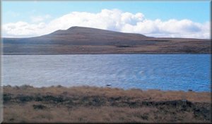 about
2km. to a wall corner at map ref. SD 746846. Here we turned right
to follow the wall up the ridge of Whernside. There is no path
shown on the map but there is a well walked path on the ground.
The path goes by the Whernside tarns and is known as the "Tarns
Route". It rejoins the public footpath at map ref. SD 741825.
From there we continued along the ridge for just over 1km to the
trig point at the summit. It was a lovely clear day with bright
sunshine and fast moving clouds, quite warm in the sun but the
fresh wind got very cold indeed by the time we reached the top
and just after the tarns we put on out top layer of about
2km. to a wall corner at map ref. SD 746846. Here we turned right
to follow the wall up the ridge of Whernside. There is no path
shown on the map but there is a well walked path on the ground.
The path goes by the Whernside tarns and is known as the "Tarns
Route". It rejoins the public footpath at map ref. SD 741825.
From there we continued along the ridge for just over 1km to the
trig point at the summit. It was a lovely clear day with bright
sunshine and fast moving clouds, quite warm in the sun but the
fresh wind got very cold indeed by the time we reached the top
and just after the tarns we put on out top layer of 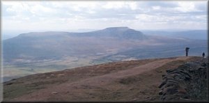 clothing
and wooly hat and gloves. The overnight ice on the pools had not
yet melted. We were very glad of the comfortable stone windbreak
with seats that has been erected just over the wall from the trig
point. We sat there for about 15 minutes for a drink and a sandwich,
looking out to a wonderful view of Ingleborough across the valley.
The scenery all round and all the way up is breathtaking, with
views into the Howgill Fells and across to the Lake District one
way and out across the Yorkshire Dales the othe way. Finally we
had to tear ourselves away from the summit clothing
and wooly hat and gloves. The overnight ice on the pools had not
yet melted. We were very glad of the comfortable stone windbreak
with seats that has been erected just over the wall from the trig
point. We sat there for about 15 minutes for a drink and a sandwich,
looking out to a wonderful view of Ingleborough across the valley.
The scenery all round and all the way up is breathtaking, with
views into the Howgill Fells and across to the Lake District one
way and out across the Yorkshire Dales the othe way. Finally we
had to tear ourselves away from the summit 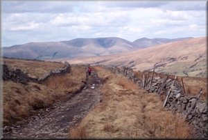 views and we headed off west on a path down to the road at map
ref. SD 722818 about 2km from the trig point. At the road we turned
right and followed the road for about 600m to map ref. SD 723823.
Here we turned left onto an old green road. It climbs up for about
1.5km and then contours round the hill. Large sections of the
green road have been badly erroded by vehicles making the walking
quite difficult. We followed it for almost 6km from the road to
a path at map ref. SD 698859 above Dent village. We followed this
path down beside the rocky gorge of Flinter Gill into the village.
We found a cafe and stopped for a coffee and a toasted teacake.
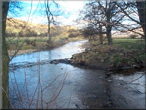
Then we walked along the road out of the village to the Dales
Way route at map ref. SD 707871. From here we followed the Dales
Way up the valley to the road at map ref. SD 721861 and then walked
the 250m up the road to our starting point at the old methodist
chapel. The whole route was about17km and took us almost 6 hours
including our stops.
views and we headed off west on a path down to the road at map
ref. SD 722818 about 2km from the trig point. At the road we turned
right and followed the road for about 600m to map ref. SD 723823.
Here we turned left onto an old green road. It climbs up for about
1.5km and then contours round the hill. Large sections of the
green road have been badly erroded by vehicles making the walking
quite difficult. We followed it for almost 6km from the road to
a path at map ref. SD 698859 above Dent village. We followed this
path down beside the rocky gorge of Flinter Gill into the village.
We found a cafe and stopped for a coffee and a toasted teacake.
Then we walked along the road out of the village to the Dales
Way route at map ref. SD 707871. From here we followed the Dales
Way up the valley to the road at map ref. SD 721861 and then walked
the 250m up the road to our starting point at the old methodist
chapel. The whole route was about17km and took us almost 6 hours
including our stops.
(top)
 |
 |
top
Route No 71d - 3 April 2003
Thornton Rust, National Trust land, Addlebrough,
Open Access land, Public Bridleway circuit - 7km
Wensleydale . . .
Map: OS
Explorer OL30 Yorkshire Dales Northern & Central areas at
1:25000
Route map from Ordnance Survey
Open Space service

|
|
|
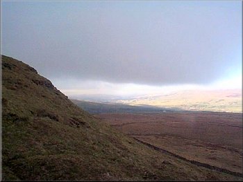
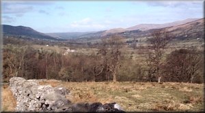
Looking up Wensleydale from the slopes of Addlebrough
There was a
low black cloud hanging over the hill but the opposite side of
Wensleydale was in bright sunshine. The final few hundred metres
to the top were quite steep and Jim was sitting on a rock having
a drink by the time I had puffed my way up. The view was impressive
with the dark cloud overhead forming a black ceiling out to the
bright sunshine beyond, quite eirie. We followed the permissive
path down to the bridleway and returned along the bridleway to
Thornton Rust. The walk had only been about 7km and had taken
us 2 hours including a stop on the top. I'm planning to use the
path over Addlebrough in a longer route soon. We arrived home
in the early afternoon in plenty of time for Jim to collect his
new car - it looks very smart in British racing green. |
Thursday
3 April was our last day and Jim was very keen to get back
early to collect his new car, after all it had been taxed from
1 April. We decided to have a short walk around Addlebrough. a
prominent hill in the middle of Wensleydale, on the way back home.
We parked in the village of Thornton Rust and set off along the
road towards the hospital. At map ref SD 961894 there was a stile
into the field with a map and a notice informing walkers of a
permissive path through the National Trust land to the summit
of Addlebrough and a permissive path through private land off
the summit to a bridleway at map ref. SD 955875.
We agreed to go over the hill instead of round it.
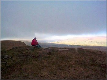
Jim at the top od Addlebrough
|
|