| 2001 walks | 2002
walks | 2003 walks | 2004
walks |
| 2005 walks | 2006
walks | 2007 walks | 2008
walks |
| 2009 walks | 2010
walks | 2011 walks | 2012 walks |
| 2013 walks | 2014 walks | 2015 walks | 2016 walks |
| 2017 walks | 2018 walks | 2019 walks |2020 walks |
| 2021 walks | 1993-2000 library | Find a Route Index |
| A few Routes to print out | Request a Route... |
Route No 41 - 5 March 2002
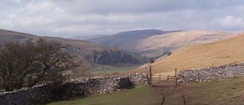
Grassington and Conistone Dib circuit - 8 miles
Wharfedale, Yorkshire Dales . . .
Route map from Ordnance Survey Open Space service.
Map: OS Explorer OL10 Yorkshire Dales Southern area. 1:25000
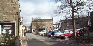 This morning
my neighbour, Jim, and I drove to Grassington in Wharfedale and
parked near the tourist information office. It was a bright sunny
morning with a strong cold wind. We set off up the village street
on the route of the Dales Way. At the top of the village we followed
the Dales Way route along the street to the left. The route used
to go through a large dairy farm at the end of the street but
it has now been diverted up a walled track to the right. We made
this turn too but here we left the
This morning
my neighbour, Jim, and I drove to Grassington in Wharfedale and
parked near the tourist information office. It was a bright sunny
morning with a strong cold wind. We set off up the village street
on the route of the Dales Way. At the top of the village we followed
the Dales Way route along the street to the left. The route used
to go through a large dairy farm at the end of the street but
it has now been diverted up a walled track to the right. We made
this turn too but here we left the 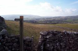 Dales
way to stay on a footpath climbing up the limestone pastures passed
a ruined farm, called Bare House on the map, until we reached
and old green road running parallel to the valley at a height
of about 400m. We kept on this green road for about half a mile
until we met another old track that climbs the hill from the village
of Conistone and continues for many miles into Nidderdale. On
the map it's called Bycliffe Road. We turned left onto this track
heading down hill towards Conistone. After about three quarters
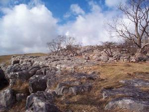
of a mile we came to an area of limestone pavement and just below
this we turned left off the main track to find a path over a
Dales
way to stay on a footpath climbing up the limestone pastures passed
a ruined farm, called Bare House on the map, until we reached
and old green road running parallel to the valley at a height
of about 400m. We kept on this green road for about half a mile
until we met another old track that climbs the hill from the village
of Conistone and continues for many miles into Nidderdale. On
the map it's called Bycliffe Road. We turned left onto this track
heading down hill towards Conistone. After about three quarters
of a mile we came to an area of limestone pavement and just below
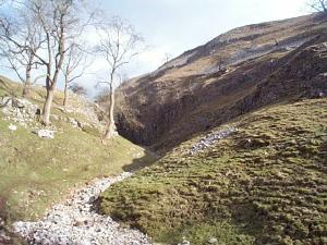
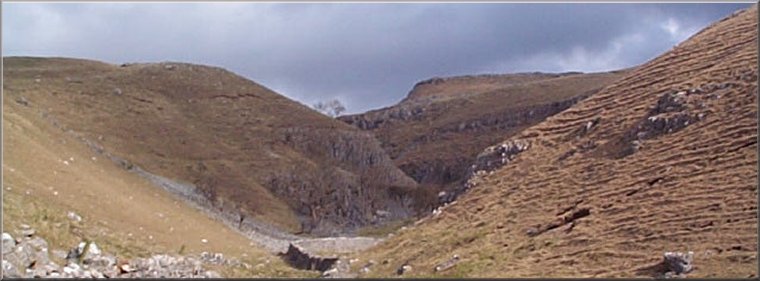
this we turned left off the main track to find a path over a 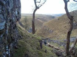 stile that then drops down a narrow limestone cleft that is in fact
the entrance to Conistone Dib - a deep limestone valley that runs
for a mile down to Conistone village. Parts of the valley are
quite wide with steep sides covered in coarse grass whilst other
parts are very narrow with sheer limestone walls only a few feet
apart and clear signs of violent erosion by torrents of water
in the distant past. It's a wonderful place. Part way down in
a wide grassy part of the dib we stopped in the shelter of a high
wall for a drink and a sandwich. There were a great many people
passing by as we sat there, more than we have seen on our mid-week
walks this year.
stile that then drops down a narrow limestone cleft that is in fact
the entrance to Conistone Dib - a deep limestone valley that runs
for a mile down to Conistone village. Parts of the valley are
quite wide with steep sides covered in coarse grass whilst other
parts are very narrow with sheer limestone walls only a few feet
apart and clear signs of violent erosion by torrents of water
in the distant past. It's a wonderful place. Part way down in
a wide grassy part of the dib we stopped in the shelter of a high
wall for a drink and a sandwich. There were a great many people
passing by as we sat there, more than we have seen on our mid-week
walks this year. 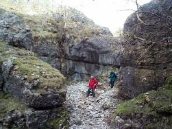 When we reached the village we turned left again back towards Grassington
and after about a hundred yards we took the path on our left climbing
back up the hillside for about a mile to cross the head of the
gorge formed by Dib Beck (where it's quite shallow and easy).
We stayed on the same path between the areas of limestone pavement
to re-join the Dales Way and continue towards Grassington. Just
before the edge of Grassington village where the path used to
go through a farm yard, we followed the diversion onto the track
above the farm and retraced our first few hundred yards back to
the car park by the information office. The whole route is about
8 miles and took us around 4 hours including our stops and a final
coffee stop in Grassington village. It's a facinating route with
spectacular limestone scenery all the way round.
When we reached the village we turned left again back towards Grassington
and after about a hundred yards we took the path on our left climbing
back up the hillside for about a mile to cross the head of the
gorge formed by Dib Beck (where it's quite shallow and easy).
We stayed on the same path between the areas of limestone pavement
to re-join the Dales Way and continue towards Grassington. Just
before the edge of Grassington village where the path used to
go through a farm yard, we followed the diversion onto the track
above the farm and retraced our first few hundred yards back to
the car park by the information office. The whole route is about
8 miles and took us around 4 hours including our stops and a final
coffee stop in Grassington village. It's a facinating route with
spectacular limestone scenery all the way round.