| 2001 walks | 2002
walks | 2003 walks | 2004
walks |
| 2005 walks | 2006
walks | 2007 walks | 2008
walks |
| 2009 walks | 2010
walks | 2011 walks | 2012 walks |
| 2013 walks | 2014 walks | 2015 walks | 2016 walks |
| 2017 walks | 2018 walks | 2019 walks |2020 walks |
| 2021 walks | 1993-2000 library | Find a Route Index |
| A few Routes to print out | Request a Route... |
Route No 153 - Tuesday
24 August 2005
Moor Gate, Hawnby Moor, Harker Gates,
Hawnby - 11km.
North York Moors
Maps: OS
Explorer OL26 North York Moors Western area at 1:25000
Route
Map on 'Landranger' base from OS Open Space service
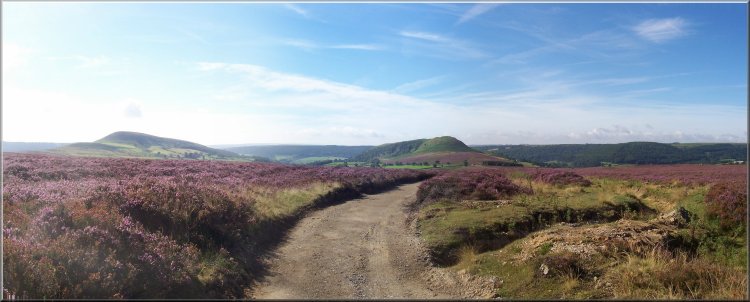
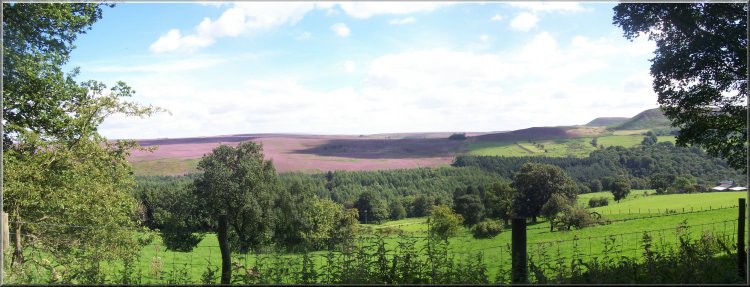
Track heading northwards from Moor Gate
towards the Bilsdale TV transmitter
It
was a fine bright day and this morning my neighbour, Jim,
and I drove to Moor Gate (map ref. SE 540917) about 2km
north of Hawnby where on 20 June this year there was a
devastating flash flood. At about 10 o'clock we set off
along the track northwards towards the Bilsdale TV transmitter.
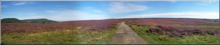
The ling heather was in full bloom giving the whole landscape
a rich purple sheen. After
about 2km we reached map ref. SE 541937 where there is
a path off to the left. We walked down the moor toward
the corner of some woodland with a row of sunken grouse
butts to our right. The path is not well defined and crosses
some quite boggy areas. About half way down the side of
the wood we turned left into the wood on a public footpath
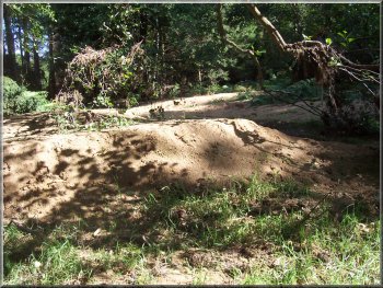
at map ref. SE 530936. There are many large wood ant nests
and the floor of the woodland is full of ants so we found
a broken stone wall to sit on for a break away from the
attentions of the ants.
|
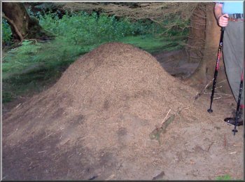
Wood ant hill |
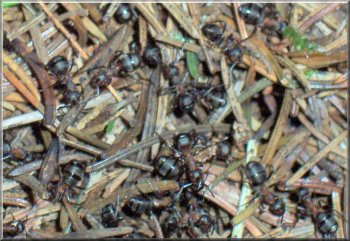
Wood ants about 10mm long |
We followed the path through the woods to the road at
map ref. SE 529928. Here we turned left to walk allong
the road for about 200m to a path off to the right. There
was a large notice informing us that the path was closed
because of the flood damage. We decided to follow the
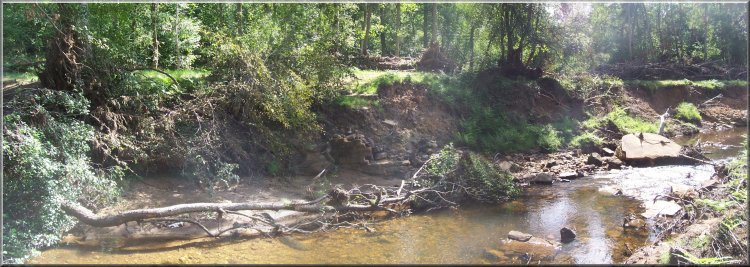
path down to the river Rye at map ref. SE 529921 to see
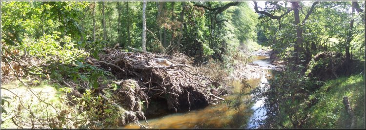
the damage for ourselves. The effect of the floods was
unbelievable! The river normally flows between 100 to
300mm deep over a stoney bed. In the flood the level must
have risen about 3m because the flood water had deposited
sand banks on top of the banks of the stream at that level.
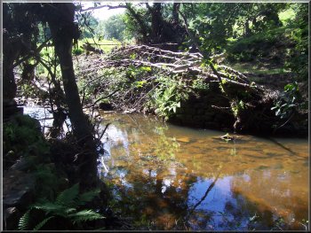
Flood debris on the river bank
|
Steel footbridge deck buried in the
stream bed
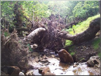
The heavy steel footbridge and its stone abutments had
gone completely and there was debris from the bridge was
visible about 50m downstream of its original site. There
were whole trees strewn along the banks of the stream
indicating the power of the flood. We managed to cross
the stream on the large stones that were all that remained
of the old ford that crossed the stream a few metres upstream
of the footbridge site.
|
Sand banks deposited about 3m above the normal
water level |
Flood debris on the river bank |
We
followed the path across the field and up the hillside
to the stile at map ref. SE 524921. Over the stile we
followed the track almost to Harker Gates. We turned off
the track on a path to our left at map ref. SE 526914.
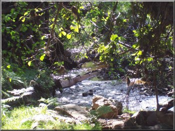
We followed the path down the hillside to the ford and
footbridge at map ref. SE 530907. The footbridge was intact
and there did not seem to bee much sign of the flood at
all.
View from the track near Harker Gates
Over the footbridge we turned right through a gate and
the scene changed. The next footbridge about 30m ahead
had gone completely and there was tree debris strewn along
the banks. We could not understand how the first footbridge
had survived - maybe it had been repaired?
|
Flood debris by the River Rye
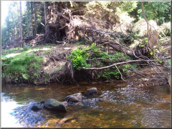
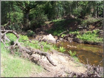
About
a hundred mtres further on the stream joined the river
Rye. The debris here was just the same as our first crossing
of the Rye about 1.3km upstream. The flood water had deposited
whole trees about 4m above the normal water level.
|
Flood debris brought down a small tributary
|
Stone bridge abutment dumped in the river
Rye |
We followed the path north for about 150m along the bank
of the river to the site of a substantial steel and stone
footbridge. The bridge had gone. The stone abutment was
on its side about 15m downstream of its original site,
Again we managed to cross the river on the stoney bed
and followed the path up the hillside to the edge of the
wood at map ref. SE 533910.
Site of a substantial stone and steel footbridge
over the River Rye (stone abutment on the right)
|
Here
we turned right to follow the path to the road on the
edge of Hawnby at map ref. SE 540897. We walked into the
village and stopped at the Hawnby Hotel for a coffee.
From the pub we crossed the road to follow the path up
Hawnby Hill to the summit at map ref. SE 540907 at 294m.
We continued along the ridge and descended to Moor gate
and back to our car. The whole route had been about 11km
and had taken us 4 hours to walk including our stops.
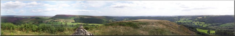
View from the summit of Hawnby Hill
|